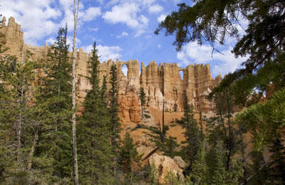
This is the Wall of Windows - you can see the two arches (windows) that gave it it's name.
|
Ken's Journal Bryce Canyon, Utah - 07/13 - 07/17/2004 |
||||
|
|
||||
|
|
|
||
Hoodoos!! |
|
|
|
Here's a shot from the day after my canyon ride of others on the same ride. You can see them marching across the center of the picture. They're about 500 feet below my position and going from your right to left. To get where they are, they just came through an arch and a steep descent from behind the formation just to the right of the column. | ||
|
This trail ride was by the only operator licensed to use the canyon - a National Park. A half-day ride, 4-5 hours, was $50. I was to find later that was not too bad a price. In Yellowstone, they want that much for a 2 hour ride. Anyhow, their are two trail ride operators working outside the park and for my second trail-ride I chose one of those. This ride was also a half-day, 4-5 hours, but cost only $40. We loaded the horses on a stock trailer at the corral in front of the campground and went to a trailhead about 5 miles away. The trail took us to the top of Henderson Point, a mountain peak just to the north of Bryce. You only had a distant view of the Bryce amphitheatre, but it was a nice ride through a fir forest. Besides the guide, a pretty 19 year-old lady, it was me and one other lady, a pretty, single, 33 year-old. It doesn't get any better than this - great scenery in the mountains and riding with two pretty ladies!! I didn't bring a camera on this ride - sorry. |
||||
|
|
||||
| Now I get to tell you about the tourists out here. It seems that Bryce and a couple other parks in the area are marketed very heavily in Europe. I talked to some of the people working at Bryce, and they estimate that at any time, more than half the visitors to the park are foreign - French, German, Dutch and some Brits. It seems that with the imbalance between the Euro and the Dollar, it's relatively cheap for a euro to take a US western vacation. You can spot them on the road because they are in a rental RV. The trip is to fly into San Diego (dunno why, maybe cheap), take a bus to Las Vegas where they rent an RV (about US$1200 a week) and hit the road. The circuit is to visit Zion first, then Bryce and finally Arches and Canyonlands out of Moab. Some continue to hit other parks, most return to Vegas after Moab. |
|
|
|
 |
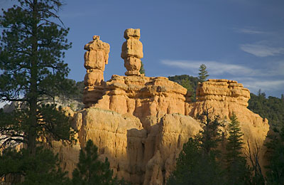
This is a shot of a couple Hoodoos in Red Canyon, just to the west of Bryce by a few miles. You drive through this canyon on the way to Bryce and you really have to pay attention to your driving. After crossing a barren high plain, plunging into a canyon composed of bright red formations just boggles the eye! This was shot in the early AM. |
|||
|
|
|
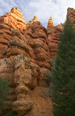
 A view up a canyon somewhere off the Pink Ledges trail. I got lost for a while. To get unlost, just go downhill until you hit the road. |
||||
|
As I indicated in Journal #11, the hit-and-run tourist could see Bryce in less than a day. Because I didn't take any time-consuming hikes, just a couple trail rides, I was done with Bryce in two and a half days. So, ready for more adventure, I struck out for a little off-road - well, off the main road anyhow. I found a 50-mile dirt road, Cottonwood Canyon Road, just east of Bryce running from Cannonville UT south through what's called the Kaiparowits Plateau to US89 some 30 miles east of Kanab UT. Near where Cottonwood Canyon hits US89 is a movie location used for a number of Westerns called Parea. Presumably, there are still a few buildings used as part of a western movie set still there. Now, one thing about traveling off the beaten path in the west. During the summer with frequent afternoon thunder storms, it pays to check with the local authorities before you try any of these dirt roads. Since I had seen a thunderstorm or two dump on the area of Cottonwood Canyon Road, I considered this advice prudent and checked with the BLM at Cannonville. I was told that although they hadn't firsthand knowledge of the condition of the road - they'd not talked to anyone traveling the road after two brutal thunderstorms in the previous couple days - they advised not to try it as it was probably washed out in a couple sections. One of the sections was right before an arch, Grosvenor Arch, that I wanted to see. So I told them I'd travel as far as I thought prudent and that I'd turn around if I got uncomfortable with the road. Well, to make a long story short - there was nothing wrong with the road. I've a 4wd high clearance and never went into 4wd. There were even some intrepid travelers out there in normal street cars - although I'm sure they brutalized the suspensions and underneath of the cars a bit. |
||||
|
|
|
||
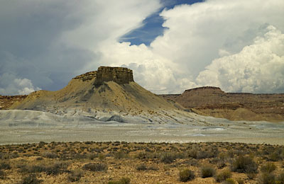
A shot from Cottonwood Canyon Road about 8 miles north of US89. |
 |
|||
|
More to follow - Stand by for Part III |
||
|
|
||
|
Page 12 |
||
| Previous Page | ||
|
|
||
|
To The Journal Index | To The Summer 2004 Index | To kenbeard.com |
||