Ken's Journal
No. 4 - Summer 2004
Yellowstone, Wyoming - 08/10 - 08/18/2004
Days 45-53 on the road. Part I.
Yellowstone Maps.
From Colter Bay Village in Grand Teton to Fishing Bridge in Yellowstone is about 60 miles, so the move was short. After setting up in Fishing Bridge Campground, almost the geographic center of Yellowstone and right on the north shore of Yellowstone Lake, I set out to orient myself to the roads and attractions.
At almost 3000 square miles (2.2 million acres), Yellowstone is one of the largest National Parks and is certainly the most varied and beautiful. New Zealand and Iceland are known for geysers, but Yellowstone has cornered the market on them with 60% of the world's hydrothermal features. Yellowstone contains the caldera of a huge volcano that last erupted some 600,000 years ago. After the eruption, the park's present central portion collapsed, forming a 30 mile by 45 mile caldera. Recently, a huge magma chamber was discovered some three miles below the surface. Measuring 30 by 20 miles and perhaps 6 miles deep, this is the engine driving Yellowstone's geothermal features - the geysers, hot springs, fumaroles and mud pots. This magma chamber is also lifting the north end of Yellowstone Lake, raising water levels at the south end and gradually flooding shore-side forests found there.
Highlights - There are five entrances to Yellowstone - from the north, the west, the south, the east and the north-east. Last year, 2003, almost half the visitors came into the park by way of the west entrance. The north entrance, by way of Gardiner Montana, is the only entrance open all year. By my count, there are 12 campgrounds in Yellowstone, 10 visitor centers, 16 guided tours, hikes and rides, 21 stores and gift shops, 10 hotels and lodges, 18 restaurants and grills, 5 service stations and 1 marina. There are 250 miles of hard-surface roads, 20 of which are closed for construction and 10 of which are one lane for construction. The maximum speed is 45 mph unless posted lower. If you get 100 yards off one of these roads, you are in the backcountry. Another 100 yards and you are in the wilderness. There are almost 1,000 miles of trails. In 2003, there were over 3 million visitors to the park, bringing the total to over 130 million since the park was established in 1872. In that year, and the few years that followed, there were under 500 visitors to the park each year!
For the first few days in Yellowstone, I stayed at Fishing Bridge (I parked at the red dot). After that, I moved to West Yellowstone, just outside the park to the west (I was outside the town a couple mile to the west on US20). Driving in Yellowstone is sometimes difficult because of the crowds. Making you way around the park was made a bit more difficult because a major road, between Canyon and Tower-Roosevelt, was closed for major re-construction. Additionally, some of the road between Fishing Bridge and Canyon was down to one lane because of construction. All this made seeing the park from one location very difficult - so I split my time between Fishing Bridge and West Yellowstone, staying a few days in each.
Find any information you need on Yellowstone at the National Park Service web-page at http://www.nps.gov/yell/ --
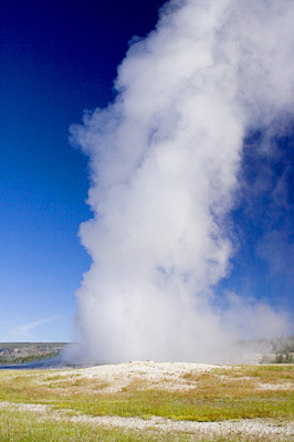
Of course, one of the things you want to do in the park is see Old Faithful Geyser. Approximately every 90 minutes or so, Old Faithful erupts. Sometimes the eruptions are more spectacular than others. Most that I saw were so-so. Don't expect to see Old Faithful without a crowd unless you do so at night.
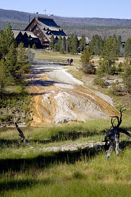
This picture is of the Old Faithful Inn from a trail across the Firehole
River, shown on the map but not labeled. The orange and white bank is a
drainage for several geothermal springs into the Firehole. The colors are
algae type bacteria that thrive in the warm to hot to scalding mineral laden
water.
