We got back to shore at about 1:30 pm and I figured I had enough time to run the 50 miles north to West Quoddy Head Lighthouse. I'd been told that East Quoddy Lighthouse was better for photos, but that was across the border in Canada and I didn't think I had time for that - So anyhow, I got a few pics of West Quoddy and can claim to have stood on what is claimed to be the Easternmost land of the United States.
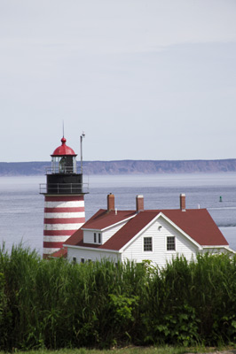 West
Quoddy Head Lighthouse - The landmass in the background is Grand Manan
Island - Canadian.
West
Quoddy Head Lighthouse - The landmass in the background is Grand Manan
Island - Canadian.
Photo Tip: What I've found about taking pictures of historic places maintained by the government - state or federal doesn't seem to make any difference - is that framing a good shot can be difficult because of all the non-historic and other visually distracting elements the agency may add to the site. This one has a chain-link fence around it, a 30' Handicapped Ramp on one side with a large blue/white handicap sign in front, a large silk banner which says "welcome" flapping in the breeze out front, a large bell in the front with a large placard describing the historical significance of the bell and a large sign on the far side of the building that says, "Easternmost point of the US." Definitely none of that is period stuff and is visually distracting in a composition. And all that's in addition to all the tourists who might be wandering in and out of your picture (as in my visit to the Prospect Point Light). So how you frame your subject becomes very important. I used the vegetation up the hill to block all the non-period stuff from view. Just to the right of this picture is a bunch of power lines running down the hill and just to the left is another of those large signs describing the site. I had a lot of problems with the Bass Head Light too. That one had a couple chain-link fences and some large red/white/blue "Gov't Property, No Trespassing" signs all over the place.
Thursday, 7/03/03, Day 15. Today is a travel day - from Trenton ME, just outside Bar Harbor ME, to Shelburne VT. The distance is some 250 miles, a short ride really. Of that 250 miles, only about 30 are freeway. The rest is on US RT 2 across the middle of ME, the top of NH and VT - lots of hills, slower speeds and stop-and-go. My fuel mileage on this leg drops to an average 6.9 mpg.
Page 20