I started today with the intention of taking part of a local historic trail called the Zuni Mountain Historic Auto Tour. Although the trail is advertised as suitable for cars, I can assure you parts of this drive are not for cars. I recommend a high clearance vehicle. FWD is not required in the dry season but judging by the deep ruts, FWD is required in the rainy season, and some sections may be impassable even with that. my intention was to do part of the Zuni Auto Tour and continue off the advertised drive into the back country to circumnavigate El Malpais.
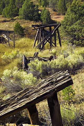
I pretty much did that. Here's a shot of an abandoned railroad trestle on the Zuni Auto Tour -- This area is all part of the Cibola National Forest - which was heavily logged (Ponderosa Pine) early in the 20th century. The railroads were built to transport the logs to mills in Albuquerque and markets in the east. In the early 1900s, the annual timber cut varied between 35 million and 50 million board feet. In the 1930s, truck logging began and railroad logging declined. By 1942, most of the commercial timber had been harvested.
This is a shot of "Bridge 17," the 17th bridge from Grants NM. The site is about a half mile off the main Auto Tour on a high clearance two-track.
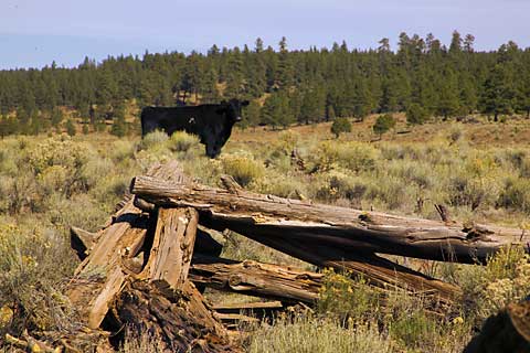 This
area of the country is mostly open range. That means that you'll find horses
and cattle grazing pretty much anywhere. You may cross "cattle-guards" that
restrict the movements of cattle, but you'll frequently find them in the
middle of the road.
This
area of the country is mostly open range. That means that you'll find horses
and cattle grazing pretty much anywhere. You may cross "cattle-guards" that
restrict the movements of cattle, but you'll frequently find them in the
middle of the road.
Here's one such free ranger bad boy who was more curious than I wanted. These animals are a little more unpredictable than your average dairy cow as they see little human presence. I took a couple quick shots and got back to my Jeep.
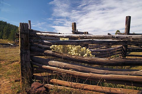
Here's a shot of a corral used to round up the cattle and load them on trucks for market -- still in use today. This is on a dirt road some 30 miles from the nearest pavement.
From here they go to a feed-lot to fatten them up and then on to processing and a special guest appearance at your local McDonald's.
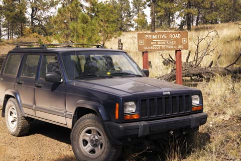
Here I am in a little more remote
area -- See the sign? Well no shit! I was trying to get to an outlook called
Oso Ridge at about 9000 feet for a look-see. What this sign doesn't tell you
is that after a couple switchbacks a half mile from here, the road is
blocked. The road is only about 10' wide and is very steep with a BIG
drop-off on one side. I had to back a half mile down off the hill. Before
that however, I did hike the quarter mile or so to the lookout - about
another 500 feet of elevation.
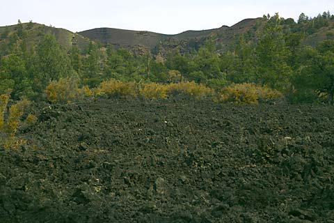
There's really not much to photograph in a lava flow - it all looks like black rock - but here's a shot of one of the flows -- This particular flow is the Bandera flow - about 10,000 years old. This flow created a 17 mile long lava tube system. A lava tube is created when the outer layer of lava cools and hardens, then insulates the flow that continues under the hard cap. Eventually the flow stops and what's left is the tube. In the background is the rim of the Bandera Crater.
I took a hike to what's called the "Big Tubes Area." After hiking about a half mile of broken lava you come to the Big Skylight Cave. It's called that because a large section of the tube collapsed, leaving a large skylight into the 60' in diameter tube (That's 60 feet in diameter!) In fact, much of the system has collapsed. Believe it or not, a lot of "cavers" climb into the remaining caves to explore. My thoughts on that? If much of the system has collapsed, the rest of it is just waiting to collapse. You won't catch me in a lava tube! I also hiked to the Four Windows Cave, where four collapses give you the impression of four giant picture windows in the roof of a tube, and to the Seven Bridges collapse where the collapses have left seven bridges over the tube. These are not what I'd call beginner's hikes. They are marked, but only by cairns (a pile of stones). Since the landscape all looks the same and there is really no horizon with unique landmarks (you're at an altitude of 8000 feet - thin air in addition to the other difficulties), so it's pretty easy to get disoriented. And since the cairns are made from the same stone as the lava flow, they're camouflaged pretty well. To start, you have to find the first cairn. Once you get to that one, you have to find the next in the chain without losing sight of the first. Basically, you have to keep two cairns in sight at all times - the one you're leaving and the one you're going to. Lose one and you could easily get disoriented and lost. There is no "beaten path" as in a lot of hiking areas as the surface is all stone. Even though a hike like this is not long, typically a couple miles at best, I use a hand-held GPS and build a waypoint chain so I can find my way out. I also carry a few extra batteries, water, sunscreen, and a small survival kit just in case.
I'm told by the rangers that a couple hiked in to the same area a couple years ago - never came out, never left any signs of their presence and were never found again. My guess is if that's true, they didn't want to be found for one reason or another. What a way to start a new life!
 I came out of the Big Tubes area on
what the Park Service calls a "primitive" road. That's a pretty good
description. Even with the Jeep, the top speed on many stretches of road
averaged about 2 mph! Progress is made slowly and carefully over lava
boulders and through deep ruts.
I came out of the Big Tubes area on
what the Park Service calls a "primitive" road. That's a pretty good
description. Even with the Jeep, the top speed on many stretches of road
averaged about 2 mph! Progress is made slowly and carefully over lava
boulders and through deep ruts.
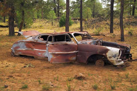
Here's a shot of one who did not make it - If you know someone in the market for an early 50's Hudson Hornet -- Have I a deal for you!
After a hour or so, I made it back to the "main" road and worked my way to the east side of the park. There I hiked out to a feature called the "Lava Falls Area." This hike was much easier as the lava was not broken - or at least not so broken as the last! This is in the McCarty's flow, only about 2000 years old.
I've no pictures of the hikes or of the lava tubes -- not knowing what to expect in terms of terrain or difficulty, I leave all the camera gear in the Jeep. Plus, everything comes out black anyhow.
I did circumnavigate the park - some 70 miles and I saw only two other cars. I also crossed the Continental Divide four times - twice in each direction!!
Saturday, 10/25/2003, Day 12.
This is a rest day. Even when on vacation, you have to have a rest day. This is time to take care of laundry, get myself and the RV ready for dry camping (Dry camping = no hookups - no electric, water or sewer), clean all the camera gear and work on the Journal.
Sunday, 10/26/2003, Day 13.
Travel day - Grants NM to Chinle AZ - 195 miles (the scenic route) - the destination is Canyon de Chelly (d'shay). My plan was to spend three days - the first day driving the north and south rims to shoot the sights from the rim, the second day on a guided 4WD tour of the canyon floor, and the third day touring the floor on horseback. The only campground within 160 miles is run by the National Park Service, is free of charge, but also free of services - nothing but a parking place - so I have to provide all my water and all my electric. This is not really a problem as I have a 5 KW generator, 70 gallons of water storage and 40 gallons each of gray and black water storage. All that, plus a good sized battery bank in the coach, keeps me going for 4-5 days. (Given that I make sure the water is full, the gas is full and the dump tanks empty.
Since this was a short hop, I took a scenic route by way of El Morro, a giant monolith of sandstone in the desert.