A travel day, Globe AZ to Willcox AZ, 120 miles, another short trip. For the most part, boring roads. US 60 from Globe to Safford, US 191 to I10 then west on I10 to Willcox. Along the way to Safford, you pass through Pima AZ - think Pima Cotton - this valley is extremely fertile and carpeted with irrigated cotton fields. It's fall and the cotton harvest is underway. Every field that's given up it's bounty is now home to a number of huge cotton bales spit out by the harvesters. These "bales" are about 8 feet by 8 feet by anywhere from 20 to 50 feet long! The field next to the local cotton processing plant is covered with these bales - thousands of tons of cotton fiber! This looks like a subject for another trip.
Willcox is the closest real town to the Chiricahua National Monument - this place is really off the beaten tourist path!
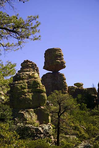
The Chiricahua Mountains began 37 MYA (Million Years Ago) when the earth's crust ruptured and spewed forth billions of tons of magma which was foamed by mixing with superheated water vapor and carbon dioxide - instant pumice. The massive eruptions were so powerful, much of the magma was blasted into tiny particles of ash. Dense, dark clouds of ash billowed above the earth. Storms developed as heat from the volcano churned the erupted water vapor. Violent winds kept the ash aloft as it passed up and down through the winds, clumping like hailstones as it moved. Eventually the clumps of ash became too heavy to stay up and fell to the earth in the area of the present Chiricahuas. (Seen today along the Hailstone trail.) Molten flow joined the clumps and piled higher and higher. Heat and compression fused the layers into a solid rock called Welded Rhyolite. From that, wind and erosion have carved the surreal spires and columns making up the Chiricahuas today.
By the time the volcano subsided, it's estimated that one hundred cubic miles of debris had been blown out of the Chiricahua volcano. By comparison, Mt St Helens blew out only 1/10th of a cubic mile of magma and the Pinatubo eruption in the Philippines blew out a cubic mile of molten rock.
The Chiricahua National Monument has an eight mile drive from the visitor's center into the middle of the mountains and several hiking trails beginning from the visitor's center and the end of the auto road. To see this place, you really have to take one of the hikes. I decided on a 9 mile hike through the heart of the monument - with a total elevation change of some 1600 feet. Nine miles on the flats is easy. With this much elevation change this is not exactly a trivial hike. This will be an all day affair. I was prepared. I carried a pack. With three quarts of water, some emergency supplies, lunch, snacks, and some camera equipment, the pack weighs in at about 15 pounds when I started. Halfway through the hike, I estimated the actual weight to be somewhat closer to 100 pounds.
Thursday, 11/6/2003, Day 24.
The park is some 35 miles from Willcox. I get an early start and see no other cars on the road after I get out of Willcox. I don't see another human being for 35 miles! I get to the Entrance Station of the park by 8:15 AM and I'm surprised to learn that a group of 30 arrived before me! At the visitor's center I run into the group of 30, buy a few maps, talk to the park people about the trails I want to hike and get on my way. I take the drive, Bonita Canyon Drive, all the way to the end, stopping occasionally to take a picture. By this time, the group of 30 is well ahead of me and I hope, far down the trail as I don't want to run in to them - unlike me, they looked like they've done this a lot. There are several trails and you can hook them together in a number of ways. I'm going to do the Echo Canyon Trail, to the Upper Rhyolite Canyon Trail to the Sarah Demming Canyon Trail, to the Heart of Rocks Loop, to the Big Balanced Rock Trail, to the Mushroom Rock Trail, to the Ed Riggs Trail, and I hope, back to where I started.
The park grades their trails from A, Easy, to D, Difficult. My trail is graded some C, most D. After finishing this hike, on their scale I would grade it G or an H. Everything goes ok until about mile 6.5 - which is after you've descended a few hundred feet and then climbed about 1200 feet -- and you're now at about 7000 feet of elevation. At that point, you notice you're thinking less and less about taking a good picture, and more and more about survival.
This is also about the same time you stop calculating how far you've come and start calculating how far you have to go. About a mile further, you notice you're counting your steps. Subconsciously, you've taken the number of feet in a mile and divided by your stride - which is easy because at this point your stride is only about a foot - and start counting the number of steps to the end. Five thousand two hundred eighty, five thousand two hundred seventy-nine, fivethousandtwohundredseventyeight . . . Owww. Now you notice that your right boot doesn't fit just right. Every step you take down hill jams your big toe into the end of the boot. Hmmm. That really hurts. Should I take off the boot and take a look at it or not? Trust me, not is the right answer. You can't do anything about it at this point anyhow, can you? So I just lace it up tighter and notice the lace is so worn that if I pull on the lace any harder, it's going to snap - and I don't have a spare with me - add that to the list for the next time. You're into a long, steep downhill now. You're thinking, ". . . damn, for every foot down hill I know I'm going to have to climb a foot uphill to get backtowhereIstarted." BacktowhereIstarted - now some mythical and maybe nonexistent destination. This has become a quest - you now ignore your pain. Now you're at the bottom of the descent and you look up the trail. Yep, up the trail because that's just where it goes -- up. Now you're counting steps between stops to rest and get your heart rate down and your breathing normal. You just know that twenty years ago, before you started abusing your body so much, you could have done this at a run - or at least at a jog. Ten more steps and I can rest again, five more, ok, stop now. Wow, got my breath back again, let's go! I know the parking lot is close now, I can hear voices - at least I think I hear them. Maybe I just hallucinate them! Wow, I can see something shiny through the underbrush - must be a car in a parking lot! Push, don't stop again. Hooray! I'm there. I've done it! Wow, pretty exhilarating! I'm really glad I challenged myself! Don't you wish you were here too?
Although I did have all these thoughts at one time or another, it was a fun hike - you just have to pace yourself and don't think you're going to set any records. I had figured about 6 hours for the hike - I actually finished in 5 1/2 - not bad. My feet hurt for the next few hours, but by the next day they had recovered with no adverse effects to my right big toe except some bruising under the nail. Of course, the first thing I did when I got back to the RV park was take a few aspirin and jump in the Jacuzzi! There's nothing that fifteen hundred milligrams of acetaminophen, a couple Scotch and waters and a half hour in a Jacuzzi can't cure.
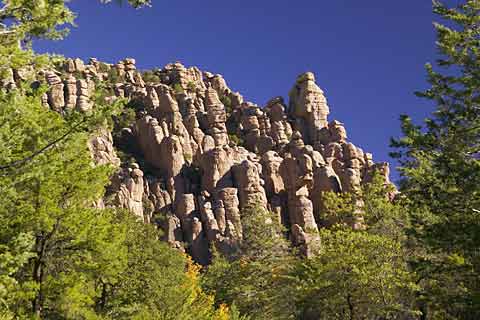
This is the first formation you see as you enter the park - it's called the Organ Pipe Formation. This is one of the few formations you can see from the park road.
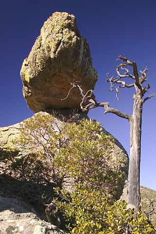
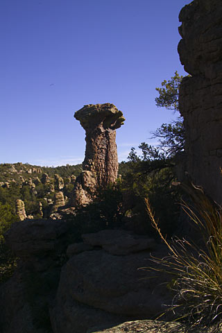
This is one of the many "balanced rocks" you'll see in the park. Actually, they aren't really balanced, but are the result of softer layers of a column eroding before the harder upper layers do. The park people claim that they are really pretty solid - I hope so because this trail goes through a bunch of them! I think that tree is holding this one in place - or maybe just tickling it's chin.
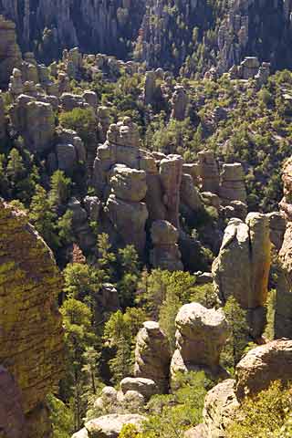
This is a view across one of the valleys. The trail is going down the side of the valley in the foreground and then will wind around through all the "hoo-doos" further down. Most of the westerners call them Hoo-doos. I don't know why but it seems appropriate.
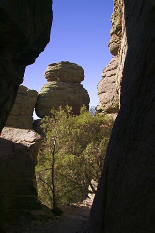
I really hope the park people are right and these things are stable - a view down the trail. Most are towering 30 or more feet over you.
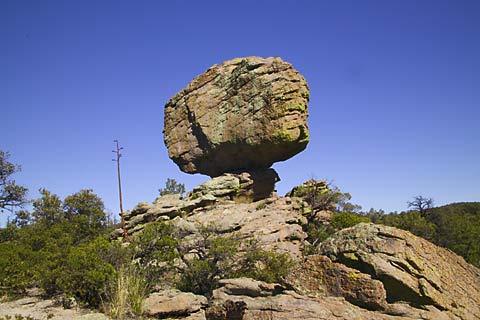
This is almost at the top of the trail - at about the 6 mile mark on my hike and at about 6800 feet of elevation. This is called Big Balanced Rock (pretty original, huh?) and is the largest balanced rock in the park. It's about the size of two school busses duct-taped together. You will not see this from the park road. Getting this close involves a hike of at least 6 miles round trip. I like a park like this - you have to be really serious about seeing anything - it keeps the riff-raff out.
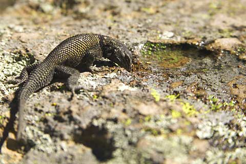
I stopped in view of the Big Balanced Rock for lunch and sat on a rock across from this critter - a spinney lizard. He kept running around on that rock checking me out. He looked thirsty so I poured some water in a depression in the rock. Without hesitation, he went over and started drinking. This one is almost a foot long - which I think is pretty good size for this kind of lizard. These things are all over the park.
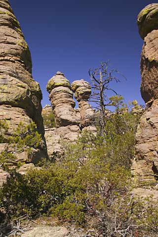
A view through the hoo-doos in the Heart of Rocks Loop. This is a large flat area at the top of the trail. The loop branches off the main trail and wanders through the hoo-doos for about a mile. In many places the trail is very faint and the cairns are inconsistent so you have to be careful to stay on track - or carry a GPS like I do - carry batteries too.
You'll never guess what they named this one. Give up? . . . . Duck on a Rock. Who'd have thunk it.
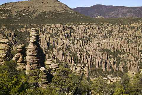
Hoo-doo Valley (my name for it). Just look at all those things marching off into the valley. . . . a Hoo-doo army.
Thor's Hammer. Hmmm, maybe from another direction, or maybe named before a couple hunks dropped off?
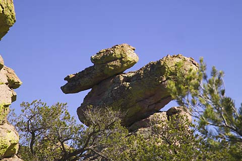
Yet another "balanced" rock.
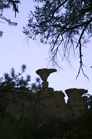
I really don't know who named these things, but this one is called a Mushroom. This was shot from deep in the forest well below the formation. This was the only unobstructed view of the thing.
I mentioned to the park people they should consider cutting down a few trees. That wasn't taken too well - you'd have thought I suggested they cut off their arm or something!!
Anyhow, that's it for the Chiricahuas. It was worth the stop just to see all the strange formations -- nature is sometimes way weirder than people are. I'm also starting to get an appreciation for geology and the birth of our world.
So now, it's back to the RV Park for a dip in the Jacuzzi -
Friday, 11/7/2003, Day 25.
I decided to spend an extra day here and skip a planned stop in Demming NM. My dirty laundry was overflowing my basket (by a bunch) and I needed to try catching up on the Journal. So anyhow, that's what I did today - laundry and BS.
Saturday, 11/8/2003, Day 26.
A travel day, Willcox AZ to Socorro NM, 290 miles. This was an easy drive. Back on I10 and head east for NM. In Demming NM, go north on NM 180 and after a couple miles, go east on NM 26. When you get to I25, go north to Socorro. NM 26 turned out to be an interesting road - just your standard state two lane but pretty much straight as a pin for some 50 miles. Set the cruise for 67 and go - but don't wander off the road - the shoulder rolls off pretty quick - enough to flip you on your side. Right before you get on I25, NM 26 takes you though the town of Hatch NM - the Capital of Chile Peppers. Amazing. Harvest time too. There are Chile peppers everywhere! They cover every roof drying in the sun, they're made into ristras and are hanging off every porch roof in town. Every square inch of open ground is planted in Chile peppers. I didn't see any machines harvesting them but I saw a bunch being harvested by hand and tossed into wagons hauled behind tractors - tons and tons of the things. This is one hot town!! This looks like yet another story for yet another trip!
Socorro NM is another of those towns like Willcox AZ - a bump on the side of an Interstate. There are two exits off the interstate, one at each end of the town with the associated Interstate conveniences - the gas stations, fast food joints, etc.
Willcox used to be a speed bump on AZ 186 before the Interstate. All other roads in the town peter out shortly outside the town limits in the desert. Socorro is the same - an exit from the interstate at each end of town with a McDonalds, a Denny's, a Motel 6 at one end of town and a Super 8 at the other. Before, Socorro was a speed bump at the intersection of NM 60 and NM 1, and all the other roads peter out in the desert somewhere. In fact, even on NM 60, it's 30 miles before you hit the next town (Magdalena) and there's nothing, really, nothing, in-between. When's the last time on the east coast you drove 30 miles anywhere without seeing signs of human habitation? If you were born here and have never been east, you'd think this country is pretty much deserted!