Ken's Journal
No. 4 - Summer 2004

Canyonlands and Arches National Parks, Moab UT - 07/21 - 07/25/2004
Days 25-29 on the road. Part III.


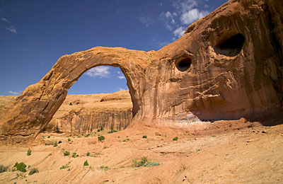
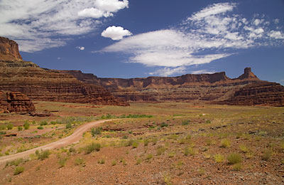
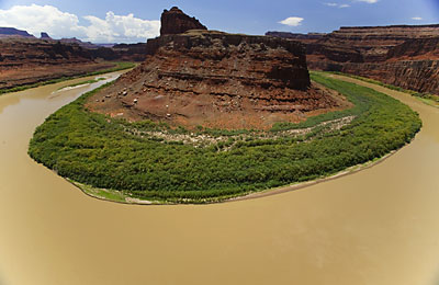
Head north out of Moab on US191 and make a right on SR128 just as you reach the Colorado River. SR128 follows the Colorado River and is a very scenic route that will eventually take you all the way to I70. All along this road are primitive campgrounds, fishing access and boat launch facilities on the Colorado. Keep going on US191 and just before the entrance to Arches NP you'll find SR279, mainly serving a potash mine and after that, the beginning of a number of back roads trails.  You'll also find a number of day-hikes off SR279. One of the nicest day-hikes is the trail to Corona Arch, a picturesque arch only 1.5 miles from the trailhead. This hike involves a climb of 440 feet and is not for anyone who fears heights as you are right on the edge of serious drop-offs in many places.

 
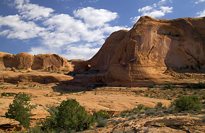
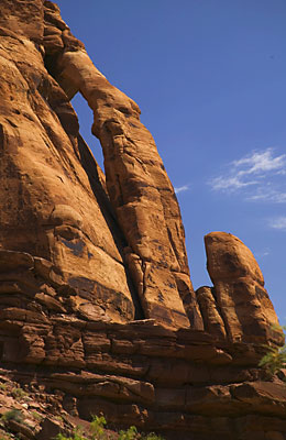
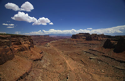
After a 400' climb out of the canyon, this is the scene that faces you. Notice the small arch near the center of the photo. This is an un-named arch. It's yours! You can name it whatever you want!!

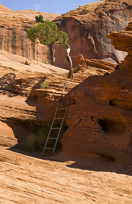
After following cairns for almost a mile and following the base of a cliff for a while, you'll find a safety cable pegged into the rock to keep you from slipping over the edge - the slickrock is steeply pitched in this area. Then you'll come to a cable alongside some steps cut into the slickrock. At the top of this climb, you'll find the ladder shown above. At the top of the ladder, you'll finally see Corona Arch.
   
On the way around the rim of the canyon to Corona Arch, you pass what's called Bow-Tie Arch, a pothole arch. This is basically a closed arch with the roof missing - erosion cut into the side of the cliff face and then the ceiling collapsed. The darker streaks are what's called desert varnish - mineral deposits carried by water run-off.


Corona Arch. The trail approaches from the other side. I crossed under the arch and hiked another ¼ mile for this picture. The opening of Corona Arch is 140' wide by 105' high.

Right behind where I'm standing to take the Corona Arch picture is a 200' drop to a railroad spur. This spur serves the potash mine further down SR279. At this point, the spur enters a one-mile tunnel that pops out of the hillside over near the Arches entrance.
There's more on the potash mine below.

 
Jughandle Arch - on the way to the Shafer Trail (Potash Road), the trail we're going to take now. This is also the bottom of the Long Canyon Trail, a trail we'll take another day. You'll miss this arch unless you get just in the right position and know where to look. The arch hugs the side of the cliff pretty tightly.

One of those more spectacular "Balanced Rocks" I spoke of in
Part I. This is near the beginning of the Potash Road. This road is an easy 2wd high clearance road - allow two hours for the 18 miles. Recent storms can make the road impassable however so check with the locals first.
 

An evaporation pond at the potash mine. Until 1964, the vast salt deposits in this area were mined underground. In 1964, a huge explosion killed 18 miners. At that time, the process was converted to solution mining. Water from the Colorado River is pumped underground where it dissolves the salt deposits. The water is pumped out into these evaporation ponds where the water evaporates and the salts are left. The water is artificially colored this blue color to hasten evaporation. The potash recovered this way is used in fertilizer and the salt remaining is used for snow removal.

   
After the potash mine, you cross a wide plain next to the Colorado River.  As a kid, when I thought of the "west", this is what I saw!
 
The Colorado River from a point called the Gooseneck Overlook. The river loops back on itself at this point. I'm actually standing with my toes on the edge of a 1,000' drop to the river. Any further back and you'd see the edge in the bottom of the picture as this is taken with an extreme wide-angle lens - 16mm. Don't try this if you suffer from vertigo. The river is flowing from your left to your right.
 
The Shafer Canyon switchbacks looking down from the Canyonlands mesa called Island in the Sky. Before this was a road, it was a cattle trail. Around 1917, John Shafer constructed a cattle trail following an old game trail. For years the Shafer's wintered their cattle on the canyon floor and trailed them to the mesa top for the summer. After uranium mining began in the '50s, the cattle trail was turned into a truck route out of the canyon. The black dot on the road in the right of the picture just after the first switchback is a full-size pickup - I know - I passed it on the way up.

(Actually, the first switchback you see is the third switchback going down - the rest are hidden under the rim.)


A view of the Shafer trail across the floor of the plain. I just came across that road.
 
A view from the edge of the Island in the Sky. you can see the sandstone bench called White Rim some 1200' below. If you drop off White Rim, after a fall of only 1000' you'll be in the Colorado River. From this point, those mountains on the horizon on the left are 35 miles away.
 

There is a 4x4 trail that follows White Rim - called the White Rim Road of all things. This trail is over 100 miles long and in a good 4x4, it'll take 2 ½ days to run - and you're on your own - this is all wilderness - bring everything you think you'll need plus anything you think you won't. If you break, an off-road tow-truck can cost up to $300 an hour - and I assure you, there is no cell service here.

If you really want to see the White Rim without off-roading, you can hike the Gooseberry Trail - only 2.7 miles one-way and it drops 1400' before hooking up with White Rim Road. Good thing I didn't have the time for this one!


Next, more around Moab - Part IV.


Page 20

  Previous Page

Next Page


To The Journal Index |  To The Summer 2004 Index | To kenbeard.com