Wednesday, 7/02/03, Day 14. I called the Puffin people last night (from the middle of Frenchman Bay while on the Schooner – cell phones are great!) to get an update on the schedule for the boat to Machais Seal Island (MSI hereafter). Actual departure depends on tides, weather, etc. The schedule is to depart at 8 am - better than the 7 am previously stated as it takes me over an hour to get there. Hooray, an extra hour of sleep!
Up at 5:30 am and on the road by 6:15 - arrive at the dock in Jonesport at 7:30 and 15 of us (in addition to the Captain and Mate) promptly leave at 8 am.
Although the island is only 10 miles from the US, it's about 30 miles or so from Jonesboro. The trip starts at 8:00 am and we're back by 1:30 pm - so that's about two hours out, two hours back and a couple hours on the island itself. MSI, as I indicated, is only 10 miles from the US. It's about 20 miles from Canada but the Canadians, years ago, built an unmanned lighthouse on the island and staff a naturalist on the island to protect the wildlife. The official NOAA Chart, #13325, Quoddy Narrows to Petit Manan, show this island clearly as part of the US. It does indicate however that there is a "horn" maintained by Canada on the island - actually it is a light and a horn. So, Canada claims ownership and so does the US! For anything but wildlife, weather research and territorial egos, the island is a worthless 20 acres in the middle of the Atlantic - actually at the mouth of the Bay of Fundy (N 44" 30.00', W 067" 05.50' if you care to look it up - you will not find it on any chart by Garmin or DeLorme - you will have to buy a NOAA chart). About two/three years ago, Canada tried to flex a little muscle to figure out who really owned the island and decided to close the island to everyone - including those who had run tours from the US for years. After a bit of newsworthy debate (in Canada anyhow) and pressure from the Department of State (DOS), and the US operator along with a bunch of US visitors "storming" the island with a letter from the US Department of the Interior, Canada decided to fall back to the status quo. Canada issued permits to those who had been running tours and now allow no more than 500 people to visit the island in a year - the season this far north is only about three months - so that's 500 visitors in three months! The island is inaccessible for the other 9 months. There is one permit for a US operator and one for a Canadian operator. The DOS issued the same kind of permits, to the same people. So anyhow, Barna Norton is the US holder of permits from both Canada and the US for our quota of visitors.
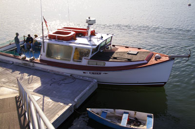
In my visit, there were 15 of us. Boarding on the boat was easy at Jonesport as it was from the float of a public dock. (Left - the larger boat in the picture is ours!) Pretty much all of the docks in this area are floaters - the tides in this area are over 20 feet on a good day!
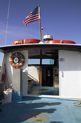
Here's a view inside the cabin - such as it is. The head was down in the bilges all the way in the front. Try using something like that while you're tossing around in the ocean! Plus, you had to hand pump the thing to flush!
Disembarking at MSI was a bit different than embarking at Jonesport - no dock at MSI!! We moored on the leeward side of the island about 100 yards offshore and were shuttled to shore in a small outboard powered rowboat, six or so of us at a time. We disembarked on seaweed covered rocks, none smaller than a basketball, from a tossing rowboat! You had to claw your way over the slimy rocks and hope you didn't toss yourself or your equipment into the rocks or the surf! As usual, I over packed and brought way to much equipment - I had a back-pack, a camera bag and a fanny pack - all packed tight with equipment.
Page 10